
We are happy to announce a CartoTalk on 14 May 2018 by Nico Van de Weghe from Gent University.
Abstract: In this Cartotalk, the interdisciplinary projects UGESCO and EURECA will be presented. In this ongoing work, an interdisciplinary approach (Natural Language Processing, Computer vision, Metadata analysis, Spatio-temporal querying and visualization, and LBS) is followed. In this cartotalk, an overview of the project will be given (with specific focus on the Geo-ICT aspects), as well as avenues for future research and cooperation.
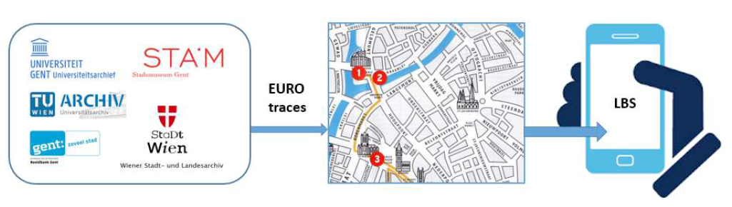
In UGESCO/EURECA, we focus on finding traces of European regions that have shaped the cities in which we live today, and we develop tools to easily explore them when visiting a city. Different historical, architectural, economic, political and cultural reasons form the base of these traces, and we use input from each of these domains to reveal the cultural heritage items that can be linked to these specific European regions/origins. The enriched metadata that is generated for the city archives and collections can be used as input to perform new fundamental research and applied studies, but also to facilitate the exploitation of the collections to a broader public and attract new groups of cultural heritage consumers. LBS that run on top of our enrichments, for example, will allow tourists to explore the traces of a specific European region (e.g. Austria) in the city (e.g. Ghent) and show them the collection items at their corresponding point of interest (POI) using their mobile device.
Nico Van de Weghe is professor in geomatics at the Department of Geography (UGent, Belgium). He is specialized in the tracking of moving objects; visualizing, analyzing and modeling of spatiotemporal information; and cognition and linguistics of moving objects. On the one hand, he has a broad experience in fundamental research with respect to handling moving objects (going from accuracy issues in data acquisition, over analyzing, reasoning, modelling and data-mining, towards visualizing and visual analytics). On the other hand, he gained a wide experience in setting up experiments in the area of Geographical Information Technology (e.g. research of the movement behaviour of persons at mass-events). Nico is author of more than 80 papers referenced on the Web-Science.
Monday, 14 May 2018, 10:00
Seminar Room 127
Gußhausstraße 27-29, 3rd floor