Congratulations to our graduates for receiving AGEO Award!

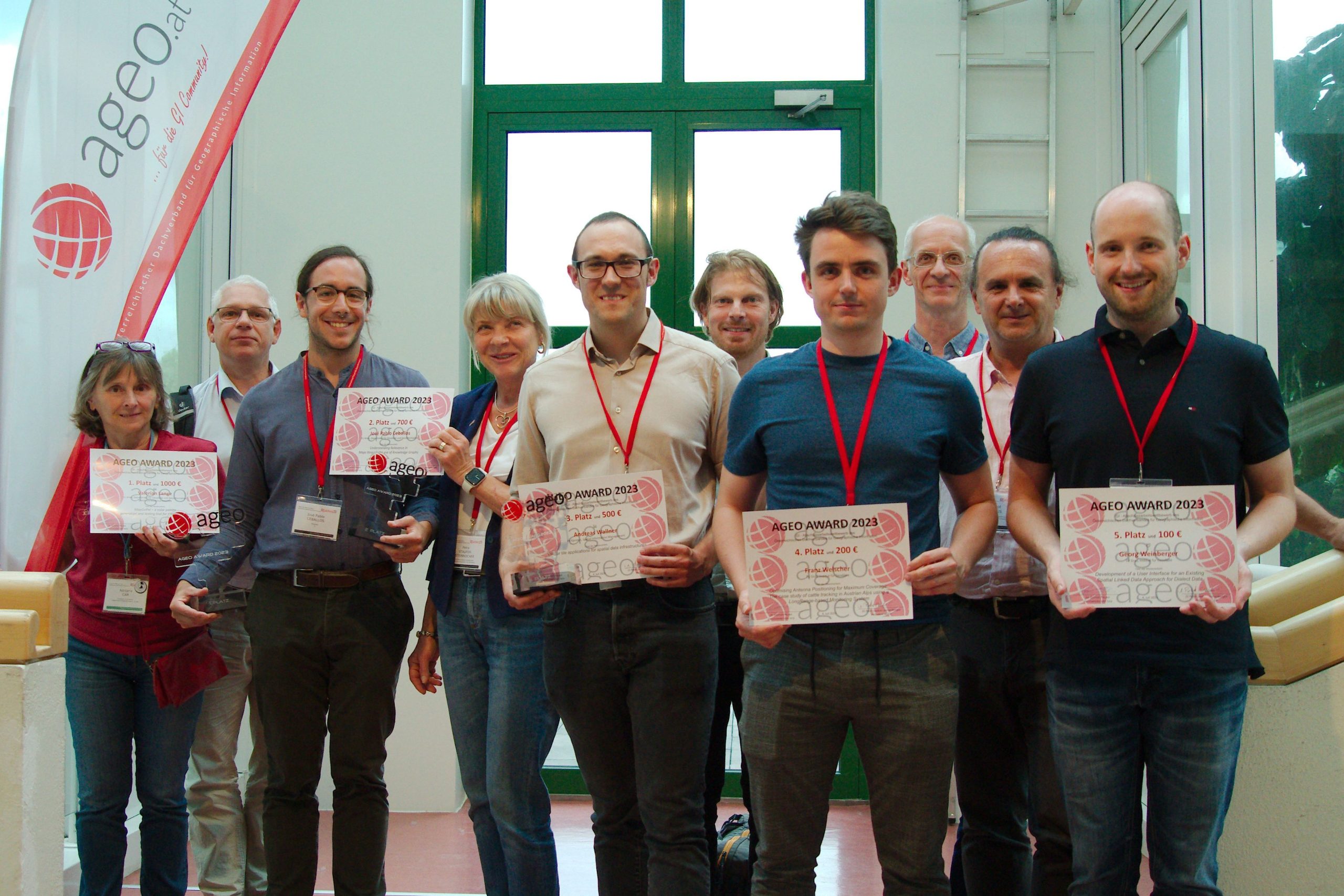
Cartography M.Sc. graduates Valerian Lange and Josè Pablo Ceballos received 1st and 2nd place in the AGEO Awards 2023 for the best master theses in the Geographic information field in Austria.

The award took place on July 4, at the GI Salzburg Conference at the University of Salzburg. This prize, awarded for the 14th time by the Austrian umbrella organization for geographical information AGEO, pursues the goal of promoting excellent graduates from Austrian universities in the field of spatial information science.

Awardees of the AGEO Awards 2023, Josè Pablo Ceballos is third from the left

The winner of the Award – Valerian Lange, a photo from his LinkedIn page.

You can find master theses on the Cartography M.Sc. website:

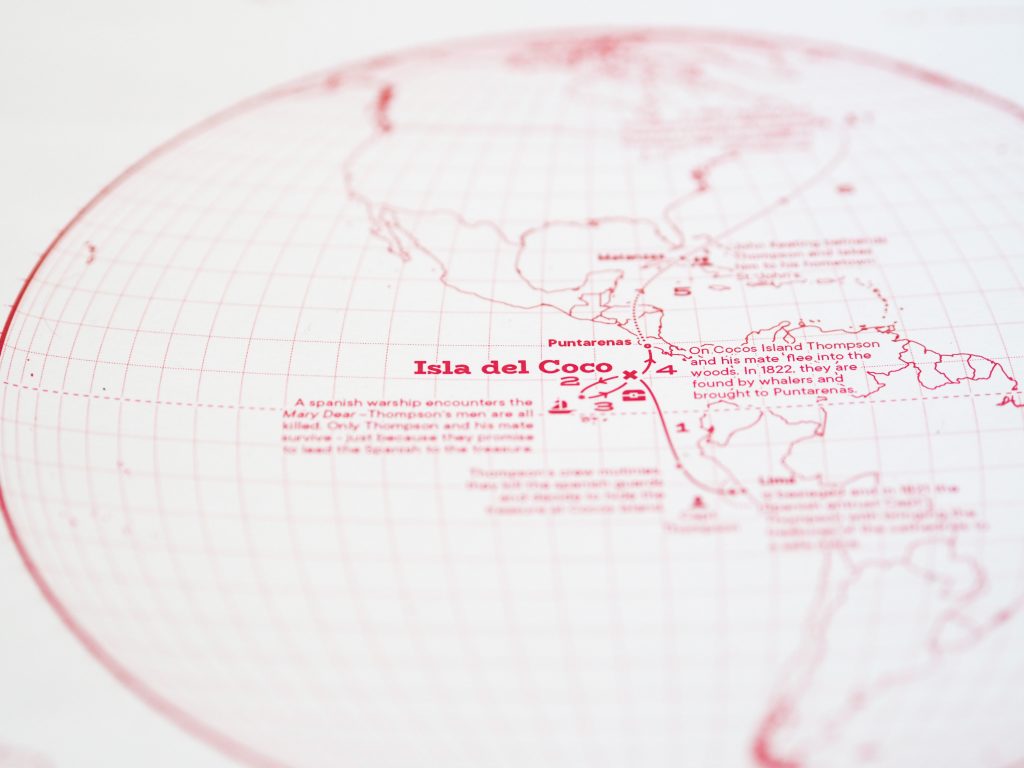
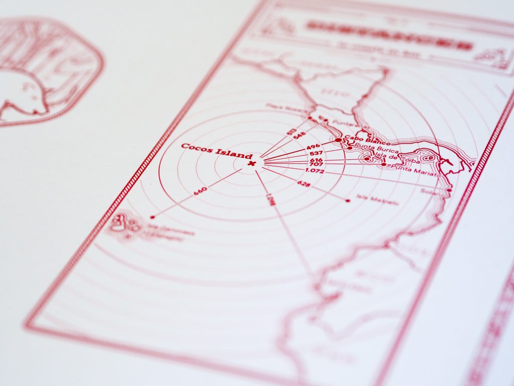
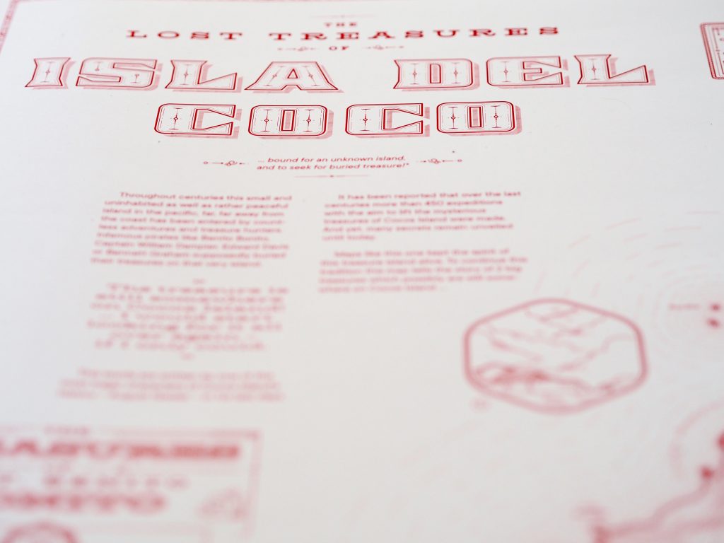
Valerian Lange’s: MapColPal – a color palette generation and testing tool for thematic maps

Josè Pablo Ceballos’: Understanding Relevance in Maps through the use of Knowledge Graphs

Henry Johns Award for Florian Ledermann

Congratulations to Florian Ledermann for winning the Henry Johns Award of the British Cartographic Society, awarded yearly for the best paper published in The Cartographic Journal. Florian’s paper “The Effect of Display Pixel Density on the Minimum Legible Size of Fundamental Cartographic Symbols” was chosen as the best paper of the year 2022.

“Part of my family has roots in the UK, so receiving this award from the British Cartographic Society means a lot to me, also on a personal level.” Florian will invest the prize money of 100£ to expand his personal collection of cartographic books and atlases.

Best Paper Award goes to Silvia Klettner

We are proud to announce that Silvia Klettner’s research on cartographic semiotics received TU Wien’s Best Paper Award 2019 from the Faculty of Mathematics and Geoinformation:

Klettner, S. (2019). Why Shape Matters — On the Inherent Qualities of Geometric Shapes for Cartographic Representations. ISPRS International Journal of Geo-Information, 8(5), 217.

Continue reading “Best Paper Award goes to Silvia Klettner”

Congratulations to Jakob Listabarth for winning at MONOCARTO 2019

We congratulate our student Jakob Listabarth for being a winner at the Monochrome Mapping Competition 2019 with his purely magenta map “The Lost Treasures of la Isla del Coco”, which he created within the class Project Map Creation this summer semester.

Isla del Coco by Jakob Listabarth
The full resolution file can be downloaded here.

From the jury statement:

When doing monochrome design, cartographers can only use one “ink” color, but most of us at least use various tints of that ink: basically, mixing it with the background color to create a continuous ramp of colors (e.g., greyscale) that we can use to distinguish rivers, contours, and other feature types from each other. Continuous monochrome is tough enough, but Jakob Listabarth takes the challenge even further and uses this map’s sole ink at 100% strength only. He is only able to distinguish feature types from each other using line weight, dot/dash patterns, and hachure shading. This he does excellently, and I continue to be impressed by how much information is shown, and how clearly each layer is distinguished from the others when they are all, after all, exactly the same version of magenta.

It’s not only an attractive aesthetic choice, but one that ties into the map’s subject. In the 19th century cartographers were usually likewise limited to representing features using ink lines, printed from engraved copper plates. Listabarth still puts a modern spin on things with the sans serif typography and charming (whimsical?) illustrations. It’s a lovely blending of old and new.

Daniel P. Huffman, competition Curator

Congratulations on your impressive work, Jakob!

Education Award: Jansa, Ortag, Schmidt ausgezeichnet

Jansa, Schmidt, Ortag

Urkunden
Urkunden

Am Department für Geodäsie und Geoinformation wird jährlich ein Preis für besondere Leistungen in der Lehre vergeben. Die Auswahl erfolgt durch die Studienkommission, die Fachschaft und den Studiendekan und berücksichtigt die Lehrveranstaltungsbewertungen durch die Studierenden an der TU Wien.

Für das Studienjahr 2012/2013 wurden am 26. November 2013 ausgezeichnet:

ao. Univ.-Prof. Dr. Josef Jansa
für wiederholt hervorragend beurteilte Lehrveranstaltungen in Bachelor und Master:
VO Digitale Bildverarbeitung in Vermessung und Geoinformation
UE Digitale Bildverarbeitung in Vermessung und Geoinformation
VU Angewandte Fernerkundung

Dipl.-Ing. (FH) Manuela Schmidt

für innovative E-Learning-Methoden auch im Bereich der Raumplanungs-Studien:
VU Thematische Kartographie in der Raumplanung
VU Internet-Kartographie
VU Multimedia-Kartographie und Geokommunikation

Dipl.-Ing. Felix Ortag

für innovative E-Learning-Methoden:
UE Grundzüge der Kartographie
VU Angewandte Kartographie
VU Geo-Medientechnik
PR Projekt Kartenerstellung

This post was automatically fetched from geo.tuwien.ac.at. Please find the original here.

Austrian Winners of the Petchenik Children’s Map Drawing Competition

A jury selected the best entries from all the maps sent to us in the national Austrian round of the Barbara Petchenik Children’s Map Drawing Competition. Check them out here [German website]!

A selection of the winning maps will be forwarded to the international round organized by the International Cartographic Association.

This post was automatically fetched from geo.tuwien.ac.at. Please find the original here.

ways2navigate mit Gender Award ausgezeichnet

Das Bundesministerium für Verkehr, Innovation und Technologie (BMVIT) vergab am 10. Mai 2010 erstmals den Gender Award an Projekte aus den Förderungsprogrammen “Intelligente Verkehrssysteme und Services plus” (IV2Splus) und TAKE OFF mit dem Ziel, die teilweise noch geringe Beteiligung von Wissenschafterinnen in den Forschungs- und Technologieprogrammen kontinuierlich zu steigern. Durch die Vorbildwirkung der prämierten Projekte soll die Bedeutung von Chancengleichheit und Gender-Aspekten in Forschung und Entwicklung (F&E) unterstrichen werden.

Wir freuen uns, dass zu den PreisträgerInnen des Gender Awards auch das Konsortium von ways2navigate gehört.

This post was automatically fetched from geo.tuwien.ac.at. Please find the original here.

First Geo Education Award

The winners for 2007/2008: Franz Zehetner and Andreas Eichhorn

The winners for 2008/2009: Gerhard Navratil and Alexander Reiterer

On December 11, 2009 the Geo Education Awards for excellent achievements in teaching in the field of geodesy at TU Vienna were awarded for the first time.

The selection process for the award is two-stage: the selection of nominees is based on the results of the student’s online teaching evaluation. The prize winners are choosen by the dean for academic affairs, the chairman of the committee for studies and two student representatives. The prize can be given to senior as well as junior teachers.

For the first Geo Education Awards ceremony the speakers were the dean for mathematics and geoinformation Prof. Dietmar Dorninger and the vice rector for academic affairs Prof. Adalbert Prechtl. In the first ceremony the awards were given for the previous two academic years.

We congratulate the winners and thank for their commitment!

More photos of the ceremony

This post was automatically fetched from geo.tuwien.ac.at. Please find the original here.