CartoTalk Amy Griffin: The user is the centre of the universe – Designing interactive maps for end users

We are happy to announce this year’s first  CartoTalk by Amy Griffin, RMIT University in Melbourne, on Monday, 23 April 2018.

Abstract: The task of the cartographer has become in some ways much easier since the advent of computers. For example, you no longer have to worry about smearing ink from your scribing pen or pasting Zipatone onto your overlay. A few clicks on a computer and it’s possible to create a basic map. Yet, in other ways cartographers face more challenges than they ever have before. People now use maps in many more places and to support many more tasks than they did in the past, and there is a bewildering array of different devices upon which maps can be displayed. Our behaviour with maps has also changed. Some people simply blindly follow where the GPS tells them to go, occasionally resulting in their injury or death (Milner 2016). Many others of us don’t bother to look at a map before we set out to find our way to a new place because we know that we can pull a phone out of our pocket along the way to check our location. And maps now respond to user inputs in ways in which they could not when they were simply printed on paper. For example, touchscreen displays coupled with internet access allow almost instantaneous and (almost) effortless panning and zooming. Yet, these new interactions lead to cognitive challenges that did not exist when viewing a paper map, whose full extent can be taken in at a glance – locating a zoomed map extent’s location relative to the full map extent.

While cartographers have directed attention to thinking about the map’s purpose and a few limited kinds of map user characteristics for some time, the philosophy of user-centred design, which systematises some of this thinking, arose in the 1980s and these ideas began to be applied more directly within cartography in the mid to late 1990s. New ideas have since expanded the remit of factors considered in user centred design to include interaction design (Cooper et al 2014), user experience design (Norman 2013), and the consideration of emotions in addition to classical cartographic thinking about map perception and cognition. In this presentation, Amy Griffin will provide an overview of the user-centred design process and the methods and techniques they use to do user-centred cartographic design (e.g., user requirements analysis, formative evaluation, eye-tracking), as well as where the state of the art stands in terms of new thinking about user-centred design as it can be applied to cartography (Roth, 2015; Griffin et al., 2017).

Amy Griffin is a Senior Lecturer in Geospatial Science in the School of Science at RMIT University in Melbourne. She’s the co-chair of the ICA Commission on Cognitive Issues in Geographic Information Visualisation. Her research interests include perceptual, cognitive and affective issues related to geographic information use, applications of GIS to historical geography, and GIScience applications to health geography. 

Monday, 23 April 2018, 9:15-10:45
Seminar room 127, Gußhausstraße 27-29, 3rd floor
CartoTalk Alenka Poplin: Empirical Experiments on Power Places: Mapping Places and Expressed Emotions

We are happy to announce a CartoTalk on Tuesday, 13 June 2017, by Alenka Poplin from Iowa State University.

Abstract: The main goal of this presentation is to explore the concept of place and the emotions felt at specific places. The places chosen for this research are power places (Kraftorte in German language), which can be defined as places in which people recharge and feel at peace, places that evoke positive feelings. Where in the city are such places? How do people/citizens describe these places? Which emotions do they experience at these places, which words do they use to describe the emotions felt at these places, and how can these emotions be represented on a map?

Our research is based on a set of mapping experiments conducted in the cities of Hamburg, Germany and Ames, Iowa. We asked people to map their power places, describe their characteristics and the feelings they feel at these places. In Hamburg we collected 191 power places, the descriptions of their physical characteristics and emotions associated with these places. We compare this European experience with data collected in a university town in the North America. The experiments were conducted with paper maps and an online volunteered geographic information (VGI) platform Maptionnaire.

The presentation addresses the issues of uncertainty; uncertainty of the location, shape of the places, and expressed emotions. It also discusses research challenges of mapping places and emotions, the need for a place-based GIS and mapping other intangible landscapes.

CartoTalk_AlenkaPoplin

Alenka Poplin is Assistant Professor at Iowa State University at the Department of Community and Regional Planning. Alenka studied Surveying and Spatial Planning at Technical University of Ljubljana before she finished her PhD  in Geoinformation Science at the Institute for Geoinformation and Cartography at Vienna University of Technology. Her research focuses on GeoGames for urban planning, serious games for civic engagement, user experience with interactive maps, GeoVisualization, Smart and Happy Cites, and Smart Communities & Big Data.

Tuesday, 13 June 2017, 16:30
Research Group Cartography
Seminar room 126

CartoTalk Anthony C. Robinson: Making Maps that Matter – New Challenges in Geovisual Analytics

We are happy to announce a CartoTalk by Anthony C. Robinson from Pennsylvania State University, on Tuesday, 16 May 2017.

Abstract: The reach and impact of cartography is more impressive than ever. Big spatial data sources, new map interaction paradigms, and scalable computing are combining to place mapping at the center of solutions to major human and environmental problems. While our discipline benefits from a tremendously rich history of scientific advances in understanding how people can make, use, and interpret maps, new gaps in our knowledge are emerging. These new frontiers are forming as a result of the torrent of data we are receiving, higher expectations from broader audiences of users, and problem contexts that are dynamic and will never have simple solutions. It is in this context that members of the International Cartographic Association (ICA) have been collaborating to develop a new research agenda for cartography in the era of big data. In this talk I will show examples of the challenges we are facing, identifying broad challenges that will require long-term research engagement as well as shorter-term opportunities that can be tackled right away. Two key themes that cut across these challenges are the need to address both the artistic as well as scientific aspects of Cartography, and to ground our work in problem contexts that truly matter to the well-being of people and our planet. Put simply, we have the opportunity to center our research on the goal of making maps that matter – an aim that can concentrate our efforts to solve important problems with geographic information.

Robinson_CartoTalk

Anthony Robinson is Assistant Professor of Geography and Director of Online Geospatial Education Programs at Pennsylvania State University. He leads Penn State’s online Postbaccalaureate GIS Certificate and Master of Geographic Information Systems programs in the John A. Dutton e-Education Institute. He is also an Assistant Director for the GeoVISTA Center in the Department of Geography. He serves as President of the North American Cartographic Information Society (NACIS), and is also the co-chair of the International Cartographic Association Commission on Visual Analytics.

Tuesday, 16 May 2017, 15:00
Research Group Cartography
Seminar room 126


CartoTalk Werner Beer: Renewing Alpine Club Cartography

We are happy to announce our next CartoTalk on Monday, 8 May 2017 by Werner Beer (Alpenvereinskartographie Innsbruck).

Abstract: More than 150 years ago the Alpine Club began to go its own way in cartography. With the onset of alpinism interest in the mountains grew as well as the need for adequate map material. Over the course of time the Alpine Club Cartography has evolved and enjoys a very good reputation in the field of high mountain cartography. In order to continue to meet expectations we are currently working on a comprehensive renewal. The lecture gives an insight into the workings of yesterday and today and shows approaches for the future.

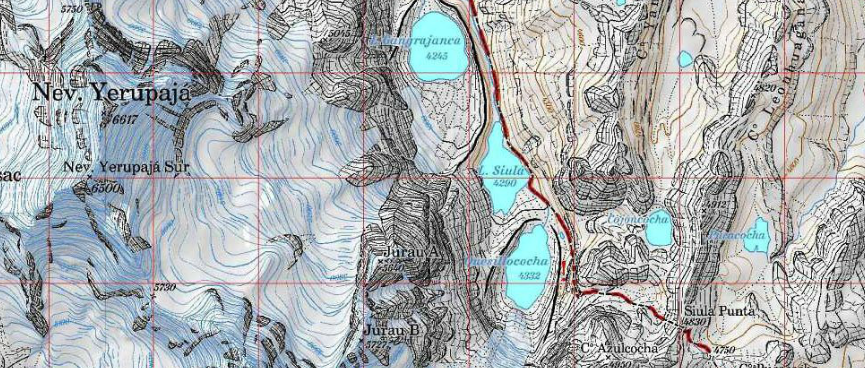
Map extract of Cordillera Huayhuash (Perú), Alpenvereinskarte, published in 2008.

CartoTalk_WernerBeer

Monday, 8 May 2017, 13.30
Geodäsie HS (EI 11)
Gußhausstraße 27-29, 3rd floor


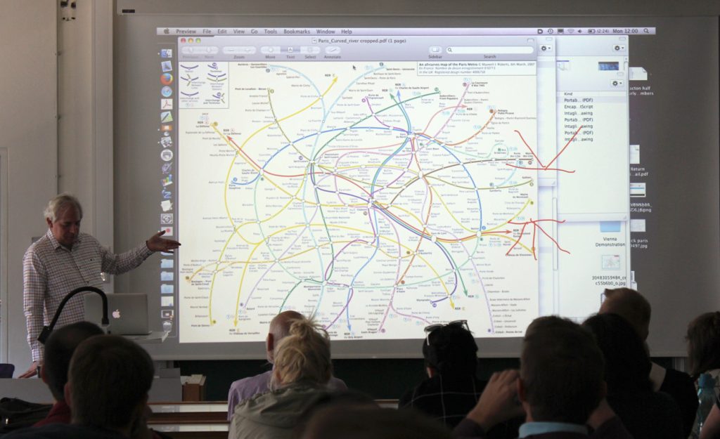
CartoTalk Maxwell Roberts: Step by Step in London and Berlin: Understanding transit maps by systematically exploring design rules

We are happy to announce a CartoTalk by Maxwell Roberts from University of Essex, UK, on Monday 10 April 2017.

In this presentation, Maxwell Roberts will discuss the criteria necessary for effective visual information design, and suggest that the optimum rules for a schematic map depend on the structure of the network, and that octolinearity may sometimes be inapproCartoTalk_MaxwellRoberts2priate. To
illustrate this, he will describe usability studies in which people’s planning performance is measured objectively using different map versions. Maxwell Roberts will also show how an exploration of design, in which rules are manipulated systematically, can highlight issues when applied to the London and Berlin networks.

For more information about his research, projects, and public lectures, visit http://www.tubemapcentral.com/

Maxwell Roberts completed a BSc and PhD in psychology at the University of Nottingham, UK, and has lectured at the University of Essex since 1993. His research interests have included reasoning and intelligence, but now focus on schematic maps. He creates challenging designs and tests their usability and aesthetics. He has authored two books on maps, and his work has been exhibited in Germany, the USA, and the UK, and is currently on display in Vienna.

Monday, 10 April 2017, 11:00
Geodäsie HS (EI 11)
Gußhausstraße 27-29, 3rd floor


CartoTalk Pepijn Viaene: Landmark-based path-finding indoors

We are happy to announce a CartoTalk by Pepijn Viaene from Ghent University, on Thursday 16 March 2017.

In recent years, there has been a growing interest in indoor navigation tools and applications. As such, various approaches to indoor navigation have been developed by research institutions (e.g. SoleWay, Nadine-navigation) and commercial companies (e.g. Eyedog, Insoft, IndoorAtlas, SPREO Indoor Navigation, Meridian). Although, these approaches often highlight the importance of landmarks, they rarely incorporate landmark-based path-finding algorithms. A major difficulty remains the identification of landmarks in indoor environments. Moreover, commonly used spatial models are not fully capable of handling basic characteristics of landmark-based wayfinding. During this talk, a theoretical approach to identify landmarks through eye tracking measures and a way to implement these landmarks in a path-finding algorithm are presented.

CartoTalk_Pepijn Viaene
Since 2013, Pepijn Viaene is a researcher at the Department of Geography, Ghent University. His PhD research is entitled “Indoor landmarks: the study and implementation of navigational aids” and deals with wayfinding and navigation in buildings. This research specifically focuses on the identification of landmarks and the use of landmarks in path algorithms and smartphone applications. Before starting his PhD, he studied Geomatics and Land Surveying.

Thursday, 16 March 2017, 11:00
Research Group Cartography
Seminar room 126

CartoTalk Trias Aditya: Geocrowd and geogaming apps for fighting fire and trans-boundary haze problems towards sustainable peatland management

We are happy to announce a CartoTalk by Trias Aditya, from the Department of Geodetic Engineering at UGM, Indonesia.

Abstract: Haze problems over Sumatera and Kalimantan have been a prolonged issue to mainly firing of drained peatland. In addition to accelerating greenhouse emission threats, the peatfire has caused health problems and major economic losses. Peat forest conversion to agriculture land by utilizing drainage canals is one of main drivers to be restored.  Water and peatland management are among the key targets for eliminating the trans-boundary haze problems. Surveying and mapping technologies such as Aerial Photos and LiDAR are required to support hydrological restoration plans in order to keep peatland in Sumatera and Kalimantan are still wet even in dry periods. Surveying and mapping activities are also required to support environmental monitoring to fight fires and canals’ development. Satellites and aerial imageries, such as satellite data and UAV, equipped with multi sensors suited to monitor haze problems, could be deployed to support haze monitoring. In addition to that, human sensors need to be activated to enable participatory monitoring. This apps will be offered to help community and decision makers fight peatfires while at the same time to support sustainable peatland management at community level.  The research study presented in this talk combines LiDAR, satellite, field and crowd data to support community-based haze mitigation. Yet, in order to raise community awareness on haze issues from fires from the peatland, geospatial-based game application was initiated through gamification and design workshop. Data from two apps, geo-crowd and geo-game are gathered and analyzed into a decision-support dashboard.

Trias Aditya completed his Bachelor of Engineering in Geodetic Engineering from UGM (1998). He received his MSc in Geoinformatics from ITC (2003) and PhD in Geoinformatics from ITC/Utrecht University (2007). His research interests include Cartography, Geospatial Data Infrastructure, Interoperable Geospatial Information System for Land Administration, Disaster Management, and Peatland Management.

Monday, 23 January 2017, 11:00
Research Group Cartography
Seminar room 126


CartoTalk Benjamin Hennig: Cartograms – an alternative map projection?

We are happy to announce a CartoTalk by Benjamin Hennig on Tuesday, 31 May 2016, where he will talk about his main research field: Cartograms.

Benjamin Hennig is the author of www.viewsoftheworld.net

We need new maps: In a world increasingly influenced by human action and interaction, we still rely heavily on mapping techniques that were invented to discover unknown places and explore our physical environment. Starting from how people can be put on the map in new ways, this talk outlines the development of a novel technique that stretches a map according to quantitative data, such as population. The new maps are called gridded cartograms as the method is based on a grid onto which a density-equalising cartogram technique is applied. The underlying grid ensures the preservation of an accurate geographic reference to the real world. It allows the gridded cartograms to be used as basemaps onto which other information can be mapped. This applies to any geographic information from the human and physical environment. As demonstrated through the examples, the new maps can show any quantitative geospatial data, such as wealth, rainfall, or even the environmental conditions of the oceans. The new maps also work at various scales, from a global perspective down to the scale of urban environments. The gridded cartogram technique is proposed as an alternative map projection that is a viable and versatile alternative to other conventional map projections. The maps based on this technique open up a wide range of potential new applications to rediscover the diverse geographies of the world. They have the potential to allow us to gain new perspectives through detailed cartographic depictions.

Benjamin Hennig

Benjamin is a geographer educated at the Universities of Cologne & Bonn and the Alfred Wegener Institute for Polar and Marine Research (Bremerhaven/Germany) where he conducted research on hyperspectral remote sensing applications in coastal ecosystems. After working as a research assistant and lecturer in human and urban geography at the Urban and Social Geography Working Group of the Department of Geography, University of Cologne (Germany) he joined the Social and Spatial Inequalities Research Group at the University of Sheffield (UK). He completed his PhD as part of the Worldmapper project with research on visualising the social dimensions of our planet. He then worked as a research assistant and then as a senior research fellow at the Department of Geography at the University of Sheffield investigating social inequalities, humanity’s impact on Earth, global sustainability and new concepts for the visualisation of these issues and now continues this work as a senior research fellow in the School of Geography and the Environment at the University of Oxford. Here he also is a member of the research cluster on Transformations: Economy, Society and Place.
more about Benjamin

Tuesday, 31 May 2016, 13:30 (1.30pm)
Gußhausstraße 25
EI5 Hochenegg

CartoTalk Anita Graser: QGIS for Cartography

We are very happy to host a CartoTalk by Anita Graser of the Austrian Institute of Technology (AIT) on Thursday, 28 April 2016.

Abstract: Since its founding fourteen years ago, QGIS has come a long way. Started as a mere data viewer, it now provides a vast array of GIS functionality, tool integration, extensible plugins, and—cartographic capability. Slighted in years past for its inability to make a “pretty” map, QGIS now provides a vast array of features for cartographers. This talk gives an overview of the current status of cartographic features in QGIS, discusses the most recent developments, and finally provides an outlook towards planned future developments.

© Anita Graser

Anita Graser is a researcher at the AIT Austrian Institute of Technology and an open source GIS advocate serving on the OSGeo board of directors and QGIS project steering committee. Her primary research interests focus on GIScience for mobility research questions, analyzing and visualizing spatio-temporal data. She currently teaches at the University of Applied Sciences Wiener Neustadt, and at UNIGIS Salzburg and the Technical University of Vienna. Furthermore, she publishes a popular blog on open source GIS at anitagraser.com and is author of Learning QGIS, and QGIS Map Design.

Thursday, 28 April 2016, 10:00
Forschungsgruppe Kartographie
Seminarraum 126