EuroCarto 2020: Sept 21-25

The Research Division Cartography is proud to be participating in this year’s EuroCarto 2020, which is hosted as a virtual event:

  • Georg Gartner: Part of the organizational committee and chairing the sessions “COVID and Methodology”, “Innovations and Applications”, and “Design”
  • Silvia Klettner: Scientific talk on “More than identifiers: Map symbols and their connotative meaning” (Sept 21)
  • Florian Ledermann: Scientific talk on “Classifying Cartographic Projections Based on Dynamic Analysis of Program Code” (Sept 24)

All contributions can be found in the detailed conference program.

The conference is jointly carried out by the German Society of Cartography (DGfK), the Austrian Cartographic Commission in the Austrian Geographic Society (ÖKK), the Swiss Society of Cartography (SGK), the University of Vienna, and endorsed by the International Cartographic Association. The conference is also recognized as an ICA Regional Cartographic Conference. For all conference details, visit the EuroCarto2020 website at eurocarto2020.org.
Thanks to our prominent guest lecturers of summer term 2020!

This summer term we had the pleasure to e-host six international guest lecturers who shared their research with our students from the International Master in Cartography:

  • Prof. Dariusz Gotlib (TU Warszawa): Selected qualities of mobile maps on the indoor navigation examples
  • Prof. Michael Peterson (University of Nebraska Omaha): Paradigms guiding Cartographic Research since the 1950s
  • Dr. Amy Griffin (RMIT Melbourne): The User is the Centre of the Universe: Designing Interactive Maps for End Users
  • Prof. Philippe de Maeyer (Ghent University): Semiology and Syntaxis in Cartography
  • Prof. Philippe de Maeyer (Ghent University): A Brief History of Cartography
  • Prof. Menno-Jan Kraak (University of Twente): Maps and Time
  • Prof. Rob Roth (University of Wisconsin-Madison): Cartographic Design and Visual Storytelling

Affective Communication of Map Symbols ‒ Paper by Silvia Klettner published in the ISPRS International Journal of Geo-Information

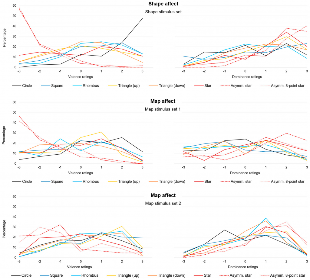
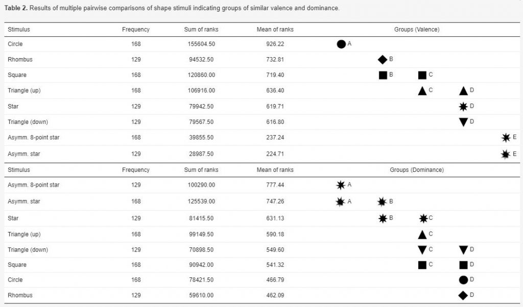
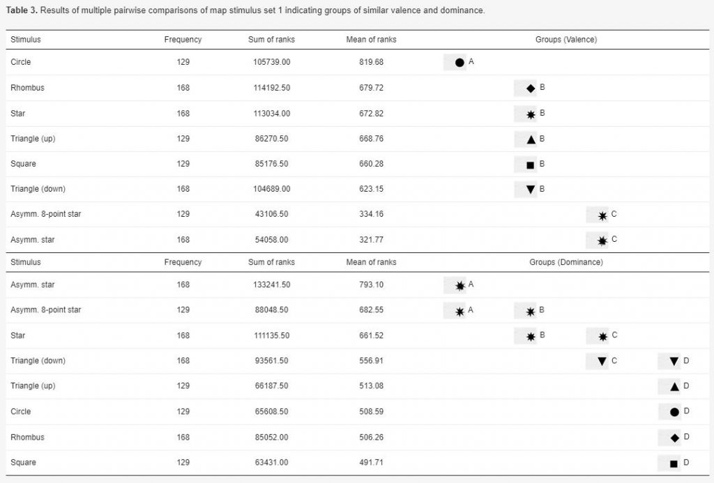
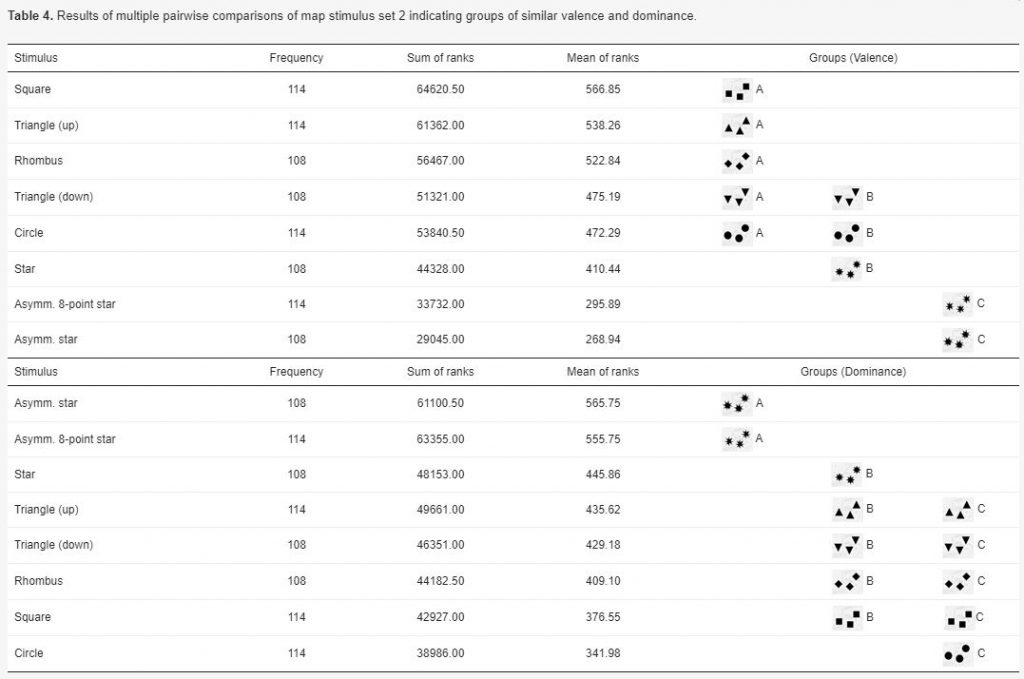
Silvia Klettner’s work on the subtle communication effects of map symbols was recently published in the ISPRS International Journal of Geo-Information in the Special Issue on Geovisualization and Map Design: Klettner, S. (2020). Affective Communication of Map Symbols: A Semantic Differential Analysis. ISPRS International Journal of Geo-Information9(5), 289.

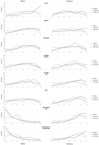
Maps enable us to relate to spatial phenomena and events from viewpoints far beyond direct experience. By employing signs and symbols, maps communicate about near as well as distant geospatial phenomena, events, objects, or ideas. Besides acting as identifiers, map signs and symbols may, however, not only denote but also connote. While most cartographic research has focused on the denoting character of visual variables, research from related disciplines stresses the importance of connotative qualities on affect, cognition, and behavior. Hence, this research focused on the connotative character of map symbols by empirically assessing the affective qualities of shape stimuli.

Preview results: 

Master thesis defense on solar shadow map

We congratulate  Georg Molzer for finishing his Master’s studies with his thesis on “Interactive Web-based 3D Solar Shadow Map“.

Nowadays, the majority of people live in cities, consisting of ever taller building structures, occluding more and more sunlight. Thus, humans are getting increasingly restricted from direct access to the Sun. This thesis claims that a tool, enabling humans to gain a better understanding of solar shadows in cities and around the world, would be beneficial. […] Such a tool should be able to consider relevant three-dimensional occluding structures such as buildings, terrain, and vegetation, as well as the actual Sun position, and visualize respective shadows for arbitrary points in time, providing predictability of solar shadows. […] Therefore, a methodology towards a capable prototype implementation is framed […].

For more details visit the project website shadowmap.org.

Well done and best wishes for your future career!

COVID19 – information for students

Dear students,

due to the recommendations of our government, we would like to inform you that:

  • classroom teaching is suspended and distance learning will be available form 16 March 2020 via TUWEL (for further information visit colab.tuwien.ac.at/display/CORONA/CORONA+Information_EN)
  • public rooms and libraries are closed until further notice
  • your lecturers from TUWien Research Division Cartography are available for you by email
  • ! update: distant learning measures are in place until 16 April 2020 extended until the end of the summer semester 2020

Please, take care and keep yourselves updated about latest developments at:

Open position in the cartography group

The Research Division Cartography is looking for a pre-doc University Assistant for 2.5 years, starting on 1 Feb 2020. All details [in German]:

Am Department für Geodäsie und Geoinformation , Forschungsbereich Kartographie E120-06 ist voraussichtlich ab 1. Februar 2020 für die Dauer von 2,5 Jahren eine Stelle für eine_n Assistenten_in, Gehaltsgruppe B1, mit einem Beschäftigungsausmaß von 30 Wochenstunden zu besetzen.
Das monatliche Mindestentgelt für diese Gehaltsgruppe beträgt derzeit EUR 2.148,40 (14x jährlich). Aufgrund tätigkeitsbezogener Vorerfahrungen kann sich das Entgelt erhöhen.

Aufnahmebedingungen:
abgeschlossenes Magister-, Diplom-, oder Masterstudium der Fachrichtung Kartographie, Geoinformatik, Informatik mit Schwerpunkt Visualization, Geodäsie bzw. gleichwertiges Universitätsstudium im In- oder Ausland

Sonstige Kenntnisse:
Die Bewerberinnen/Bewerber müssen zum Zeitpunkt des Stellenantritts ein einschlägiges Diplom- oder Masterstudium im Bereich der Kartographie, Geoinformatik, Informatik mit Schwerpunkt Visualization, Geodäsie oder Geographie abgeschlossen haben.
Der/Die Stelleninhaber/in soll im Bereich von Kartographischen Informationssystemen, insbesondere im Kontext von Location-based Services, arbeiten. Daher soll sie/er über sehr gute Kenntnisse in diesem Bereich sowie von Kartographischem Design, Methoden des WebMapping und von Visualization-Techniken verfügen. Außerdem sind sehr gute GIS und Programmierkenntnisse (bevorzugt JavaScript und Python) erwünscht. Für weitere Auskünfte zu dieser Ausschreibung stehen Ihnen Prof. Dr. Georg Gartner ( georg.gartner@tuwien.ac.at ) zur Verfügung.

Bewerbungsfrist: bis 16.01.2020
Bewerbungen richten Sie an die Personaladministration, Fachbereich wiss. Personal der Technischen Universität Wien, Karlsplatz 13, 1040 Wien, Onlinebewerbungen an barbara.triebl-kraus@tuwien.ac.at
Die Bewerber und Bewerberinnen haben keinen Anspruch auf Abgeltung angefallener Reise- und Aufenthaltskosten, die aus Anlass des Aufnahmeverfahrens entstanden sind.