
Courses of SS 2011 are online in the teaching section.
Bachelorarbeitsthemen 2011
Die folgenden PDF-Dokumente enthalten allgemeine Informationen sowie Bachelorarbeitsthemenvorschläge für Studierende des Bachelorstudiums Geodäsie und Geoinformatik.
Themen Geoinformation
Themen Geophysik
Themen Höhere Geodäsie
Themen Ingenieurgeodäsie
Themen Kartographie
Themen Photogrammetrie und Fernerkundung
This post was automatically fetched from geo.tuwien.ac.at. Please find the original here.
CartoTalk László Zentai
We are happy to welcome László Zentai of the Department of Cartography and Geoinformatics of the Eötvös University Budapest to our colloquium CartoTalks:
Are we ready for Cartography 2.0?
Application of Web 2.0 in cartographic education
The term web 2.0 was first used in 2004 on a conference where the organizers focused on the new generation web services. Although web is not software and it hasn’t had versions everybody has understood this term and also understood the real meaning behind it.
In the last 30 years cartography has considerable changed and we may think to use the similar term for our science: cartography 2.0.
Even web 2.0 is not a clear easily definable term we can list new features of the web which has formed this new term. Wiki, blog, RSS, mashup applications, social networking are the key features (and other less notorious are still under development) which are not concrete application, but rather philosophies.
One of the most prominent mashup application are the web-sites which are connected to GoogleEarth or similar services to use their basemaps/satellite images to add their own geographically located contents. These applications are also used by non-cartographers to help them to “make maps”.
Are these new features enough to introduce the new term: cartography 2.0?
Friday, December 3 2010, 10.00 am
Seminar room 126
Research Group Cartography
Erzherzog-Johann-Platz 1, 1040 Wien
This post was automatically fetched from geo.tuwien.ac.at. Please find the original here.
OVG-Jahresabschluss 2010
 Im Rahmen des diesjährigen OVG-Jahresabschlusses wurde ein “Geodäsie und Geoinformations-Tag” mit der Fachschaft für Vermessung und Geoinformation der TU Wien sowie dem Studiendekan für Vermessung und Geoinformationan der TU Wien am Mittwoch dem 1. Dezember als zentrale Veranstaltung für unsere StudentInnen und MitarbeiterInnen organisiert.
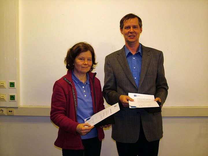
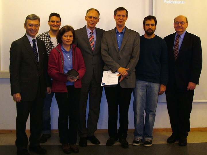
Im ersten Teil fand eine Informationsveranstaltung mit studienrelevanten Informationen statt, in der auch die Auszeichnung für die beste Lehrveranstaltung des Studienjahres 2009/2010 vergeben wurde. Die Geo Education Awards wurden für besondere Leistungen in Lehre und Ausbildung im Bereich der Studien für Vermessung und Geoinformation an der TU Wien auf Grund von Lehrverantaltungsbewertungen letztes Jahr gegründet. In einer zweiten Runde wurden die endgültigen Preisträger aus den nominierten Lehrveranstaltungsleitern schließlich durch eine Jury, bestehend aus dem Studiendekan, dem Vorsitzenden der Studienkommission und zwei Fachschaftsvertretern festgelegt. Dabei wurden auch die langjährigen Ergebnisse aller Lehrveranstaltungsbewertungen für diesen Lehrenden berücksichtigt.
In Beisein von Vize-Rektor Prof. Prechtl und Dekan Prof. Dorninger wurden den Preisträgern für das Studienjahr 2009/2010, Herrn Prof. Weber und Frau Prof. Schranz-Kirlinger, im Rahmen einer kleinen Feier die Auszeichnungen überreicht.
Anschließend wurde der OVG-Jahresabschluss mit Kurzvorträgen begangen:
Stadtvermessung Wien (MA 41)
Hauer & Stix ZT GmbH
Korschineck & Partner Vermessung ZT GmbH
SynerGIS Informationssysteme GmbH
rmDATA GmbH und
GEODATA Ziviltechnikergesellschaft mbH
Jede Firma hatte ca. 10–15 Minuten Zeit sich und Ihre Anforderungen als Arbeitgeber für die StudentInnen vorzustellen (was künftige Mitarbeiter können sollten und erwarten können).
Als Ausklang der Veranstaltung wurde bei einem gemütlichen Beisammensein mit Buffet und Getränken Gelegenheit zum weiteren gegenseitigen Kennenlernen gegeben.
This post was automatically fetched from geo.tuwien.ac.at. Please find the original here.
Gender in der technologieorientierten Forschung
Wir freuen uns, zusammen mit unserem Projektpartner Salzburg Research im Rahmen des Forschungsprojekts FEMroute folgenden Vortrag anzukündigen:
Gender-Dimension in technologieorientierten Forschungsprojekten –
am Beispiel von FEMroute
von Drin Bente Knoll, Gender-Expertin, Knoll & Szalai OG
Der erste Teil des Vortrags beleuchtet die Herangehensweise und die Prinzipien beim Vorgehen, wenn die Gender-Dimension als integraler Bestandteil in technologieorientierten Forschungsprojekten Berücksichtigung finden soll. Neben dem Blick auf die forschenden Personen und deren Interaktionen in Forschungsprojekten ist es relevant, Zielsetzungen, Methoden, Inhalte, Zielgruppen, (potenzielle) NutzerInnen und AnwenderInnen des Forschungsvorhabens auch aus der Gender-Perspektive zu betrachten.
Der zweite Teil des Vortrags beschäftigt sich mit der Thematisierung von Gender im Rahmen des Projekts FEMroute, dessen Hauptziel es ist, genderspezifische Kontexte in mobilitätsunterstützenden Systemen wie Routenplanern oder Navigationssystemen zu berücksichtigen. Das Projekt, das von Salzburg Research in Kooperation mit der Forschungsgruppe Kartographie der TU Wien durchgeführt wird, wird von Knoll & Szalai während der gesamten Projektlaufzeit als externe Gender-Expertin betreut. Neben inhaltlichen Überlegungen zu Gender-Aspekten im Mobilitätsverhalten von Frauen und Männern wird auch der Gender-Awareness-Raising-Prozess innerhalb des Projektteams dargestellt.
Mittwoch, 24. November 2010 um 16:30 Uhr
Vortragsraum der TU-Bibliothek (Resselgasse 4, 5. Stock)
Eine Anmeldung ist nicht erforderlich, bei Fragen wenden Sie sich bitte an Manuela Schmidt.
Gerne kümmern wir uns um die Kinderbetreuung. Bitte bei Bedarf bis 16. November bei Manuela Schmidt anmelden und das Alter des Kindes / der Kinder angeben.
Finden Sie hier die Vortrags-Einladung als PDF.
This post was automatically fetched from geo.tuwien.ac.at. Please find the original here.
All thesis topic proposals now in TISS
All our proposals for topics for thesis (bachelor, master) are no longer available on our site but via TISS. For the link and some more details, visit our teaching page.
CartoTalk Jesús Reyes
We are happy to welcome Jesús Reyes of the Department of Cartography and Geoinformatics of the Eötvös University Budapest to our colloquium CartoTalks:
Alternative Solution for Data Visualisation
This presentation includes methods of representation less known and less used in thematic cartography: the cartograms and the Chernoff method.
The method of thematic representation named cartogram is one of the youngest methods in the-matic cartography (but specialists in map history affirmed that old maps as the Tabula Peutingeriana can be also considered a cartogram). Its origins are dated to the first years of the 20th century, but the first cartogram-like representations were made after the second half of the 19th century. During the 20th cen-tury numerous methods were created to make cartograms, beginning from the traditional calculation published by Erwin Raisz in his textbook “General Cartography” in 1938. The use of computer techniques in cartography (mainly of personal computers from the 1980’s) gave a new and decisive impulse to the making of cartograms (Tobler, 1983). From the last decade of the past century new, internationally ac-knowledged methods were developed by cartographers or specialists from research fields near to car-tography: Daniel Dorling (Cellular automata machine method and circular cartograms), Sabir Gusein-Zade and Vladimir Tikunov (Gusein-Zade and Tikunov method to construct contiguous cartograms), Michael Gastner and Mark Newman (diffusion-based cartogram).
In 1973 Hermann Chernoff (who at present is Professor Emeritus of Applied Mathematics, from the Department of Statistics at Harvard University) created a method for the graphic representation of statis-tical data in specific multivariate data on only one symbol (a human face) changing its features. Only four years later, from 1977 this method of representation began to be introduced also to cartography abroad, using the human faces to represent data on a map according to the traditional methods of thematic rep-resentation. Along the last two decades new maps were made taking advantage of the technological development represented by the daily use of personal computers in the research related to thematic cartography.
Some examples about international research on this theme and the general use of this method on maps are also included in the presentation, e.g. works as the map made by Sara I. Fabrikant (Department of Geography, University of Zurich) or the use of Chernoff faces as component of a cartogram (research finished by Daniel Dorling from the Department of Geography, University of Newcastle upon Tyne). Some of the practical experiences acquired during the theoretical and practical teaching of this method for MSc students on Cartography at Eotvos Lorand University are also presented. These experiences are illustrated by some thematic maps made by the students using the original Chernoff faces and it’s adap-tation to represent data on maps. Some new proposals about the possible future use of the Chernoff faces in school cartography (mainly on thematic maps in school atlases) are also conceived, more exactly how to adapt the original Chernoff method for its use on maps made for pupils in Elementary and Sec-ondary Schools, modifying the original method in interest of improving the map reading. These ques-tions were studied within an international project counting with the participation of Argentine and Hun-garian specialists, which is also presented briefly and the research follows within an Austrian-Hungarian bilateral project during 2010 and 2011.
Friday, October 29 2010, 11.30 am
Seminar room 126
Research Group Cartography
Erzherzog-Johann-Platz 1, 1040 Wien
This post was automatically fetched from geo.tuwien.ac.at. Please find the original here.
CartoTalk Karsten Hoffmann
On 29 October 2010 Karsten Hoffmann from the University Osnabrück gave a CartoTalk entitled
Web Mapping 2.0
This post was automatically fetched from geo.tuwien.ac.at. Please find the original here.
New project EmoMap
We are happy that our project EmoMap got funding by FFG. In the project we aim to collect data about emotional perception of space and use it to improve pedestrian navigation systems. Find out more!
This post was automatically fetched from geo.tuwien.ac.at. Please find the original here.
WildUrb is online
 The online community platform for pedestrians is online. Research Group Cartography is involved in the project as a consultant.
Go check it out: wildurb.at [German]